National Weather Service
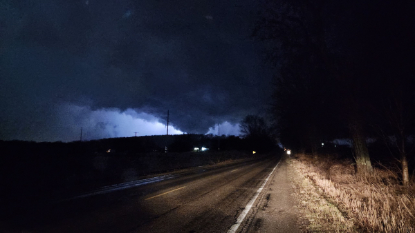
This is a Feb. 27 tornado in MarshallBy CLARA LINCONHOL
Capital News Service
LANSING — The lack of ice on the Great Lakes this winter could cause thunderstorms and tornadoes to occur earlier than usual in the region.
Michigan is expected to see more severe weather in April and May, said Paul Pastelok, a meteorologist for AccuWeather. Historically most of the state’s severe weather begins in mid-June to early fall due to Lake Michigan’s influence on its weather patterns.
And as climate change has led to less ice on the lakes, safety officials express concern about the increasing risk posed by severe weather.
Michigan already saw two tornadoes in February, unusual for the time of year, according to the National Weather Service. On average, Michigan sees 15 tornadoes per year, according to the State Police’s emergency preparedness program.
Atmospheric instability is one ingredient needed for severe storm development, Pastelok said
During the spring, the Great Lakes typically act as a stabilizer. Water temperatures and air masses above the lakes are usually much colder than the warmer air masses above the ground.
“You get lake breezes and cooldowns that cause more stability in the atmosphere, and so you don’t get as much thunderstorm activity,” Pastelok said
But this spring, the lakes will probably act as a destabilizer, he said. They’ll warm up more quickly due to the absence of ice. They have a head start,” he said.
“This year we think the waters can warm up quick enough that there can be some elevated instability faster in the late spring, so that would cause the thunderstorms to develop a little faster than what we would typically see,” Pastelok said.
The Great Lakes had record low ice coverage this winter, according to the National Oceanic and Atmospheric Administration. Upper Midwest states like Minnesota, Wisconsin and Michigan experienced their warmest winter on record, according to the Prism Climate Group, an organization that generates datasets from climate data.
As storm systems travel northeast, the air above the lake can influence the strength and organization of storms as they pass into Michigan.
That’s why Michigan had two February tornadoes, Pastelok said. “Because of the warm temperatures and the lakes not being ferociously cold, we just had that good setup.”
Other factors also determine if severe storms form, he said. Higher dew points, or the temperature in which air must be cooled for dew to form, and wind shear — which is the change in wind speed and direction as you go higher into the atmosphere are some.
The higher the dew point, the more “muggy” or humid it will feel outside, according to the National Weather Service.
The role the Great Lakes play in weather patterns varies. Sometimes they can dampen the potential for severe weather, while other times they enhance its potential. It all depends on the temperature of the air above the lakes and how it compares to the air above the ground, said Kevin Doom, a meteorologist at the National Weather Service’s Chicago office.
“The lakes can have an effect for sure. They don’t always, but they can have an effect, and not always the same effect,” he said.
Weather forecasters look for where storm ingredients intersect. Warm moist air near the ground, cool dry air aloft, horizontal winds and a mechanism that lifts storms, like a front or dry line — a line that separates moist and dry air, catch meteorologists’ attention, said Harold Brooks, a researcher at the National Severe Storms Laboratory in Oklahoma.
“Basically they’re looking for where the ingredients are now and what processes are taking place,” he said. “If one of the ingredients is absent, what are the processes that might bring that ingredient into place?”
Warm moist air from the ground is lifted, cools slightly as it rises and becomes saturated, forming clouds. Moist air is warmer, and less dense than the dry air around it, causing it to rise. Thunderstorms form when warm, moist air rises through cooler, dry air, Brooks said. “It shoots up just like a rocket because it is buoyant.”
Less ice on the lakes impacts the air temperatures of interacting air masses leading to more favorable conditions for thunderstorm development.
When it rains, cooler air is brought down while air higher up becomes warmer. Thunderstorms reduce the gradient of temperatures in the atmosphere and eliminate imbalances, Brooks said.
Pastelok said that although the Great Lakes region doesn’t experience as many tornadoes as the Great Plains states, they do happen and people need to be prepared for severe weather this spring.
“You always have to have a plan no matter where you are in the country just in case something like that happens,” he said.
Tornadoes can develop with little warning and can be difficult to see, said Pete Duncanson, vice president of training and product development for ServiceMaster Restore, a company that helps communities rebuild after severe weather events.
“It only takes a second for (a tornado) to drop from the air and begin a devastating path,” Duncanson said.
Clara Lincolnhol reports for Great Lakes Echo.