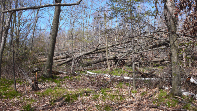

Blowdown at Sleeping Bear Dunes during the summer of 2015. Image: Al Kirschbaum.
By NATASHA BLAKELY
Capital News Service
LANSING — For the first time, the National Park Service is collecting data to monitor and find patterns in fires, trees blown down by wind and other events that affect national park landscapes, including Sleeping Bear Dunes National Lakeshore, Isle Royale National Park and Pictured Rocks National Lakeshore.
“There’s a general thought that these parks are the last vestiges of natural area, and the areas around the parks are affected by humans, but a lot of times it isn’t quantified,” said Al Kirschbaum, a remote sensing specialist with the Park Service and the project’s lead researcher. “There’s not a lot of numbers associated with it, so that’s where our work came into play: to see if we can quantify disturbances.”
Eric Pfaff, an expert interpreter consulted for the project, said: “People, they like national parks. They enjoy the experience of going to them, so how they’re impacted by various things is important. … There’s been more stress on the parks from the number of visitors. They try to keep it as pristine as possible, but it’s getting harder.”
That’s where the project comes in. Data on the impact on landscapes of disturbances both inside and outside the parks will help park managers better maintain the public lands for the ecosystem and for the visitors.
The disturbances being monitored are natural and non-natural occurrences that affect the vegetation, such as trees blown down (blowdowns), timbering, fire and development.
Though a lot of effects can be negative, disturbances can have positive impacts, Kirschbaum said.
Fire and beavers, for example, play key roles in developing habitat by changing the structure or composition of the landscape, according to Kirschbaum.
Similarly, some human-induced disturbances are better for the environment than others. Sustainable forest harvest can aid the regeneration of a forest, while land development for things like parking lots does not. Cataloging the disturbances will help with assessing if an impact is beneficial or not.
The Park Service implemented a monitoring system that involves studying satellite images of disturbances and then confirming those disturbances in person. Kirschbaum and his colleagues then quantify the amount, type and location of those disturbances inside and outside of the parks.
“It’s important for us to know that development isn’t occurring in some of these areas. For managers to better manage what’s happening inside their parks, they need to know what’s happening outside their borders,” Kirschbaum said. “For example, over-harvesting watersheds can lead to sedimentation in national parks. The data can be used to determine if they should advise shifting focus away from a particular watershed.”
The study encompasses the first round of data including six years of disturbances at each of eight Upper Midwest parks, using data from the 2000s. The exact series of six years differed for each park. Available satellite imagery goes back to 1985, but they’ve finished analysis for the data from 1995 to 2013 at this point, Kirschbaum said.
The research will eventually include data from nine national parks and sites in the Upper Midwest—Isle Royale, Pictured Rocks and Sleeping Bear Dunes in Michigan; Apostle Islands National Lakeshore and St. Croix National Scenic Riverway in Wisconsin; Indiana Dunes National Lakeshore in Indiana; and Mississippi National Recreation River Area, Voyageurs National Park and Grand Portage National Monument in Minnesota. The researchers did not get to data from Grand Portage in time for their first study.
“With all the map services people are using, people have a greater and greater awareness of spatial information,” said Ulf Gafvert, the Park Service’s geographic information services coordinator who did validation and photo interpretation on the project. “Being able to see in a spatially explicit manner the pattern of changes on the landscape – it’s fascinating to be able to observe.”
The National Park Service isn’t using public data or citizen science at this point in the project, but that doesn’t mean the public shouldn’t be invested in what’s happening around the parks, Kirschbaum said.
“It’s good for the public to be involved and ask questions and hear the answers these professionals have and have that dialogue,” he said. “And if they notice something going on, that’s something to report to the Department of Natural Resources or to the appropriate agency.”
Natasha Blakely writes for Great Lakes Echo.