By CHELSEA MONGEAU
Capital News Service
LANSING – At the bottom of Chris Lowry’s research project homepage is a bold motto: “We
are all scientists.”
It’s a mantra that Lowry, an assistant professor of hydrogeology at the University of Buffalo in New York, follows while seeking to understand how water moving through watersheds changes over time across the Great Lakes region.
Lowery can’t collect data from more than 50 places at once by himself, so he’s recruiting “citizen scientists” in Michigan, Wisconsin and New York.
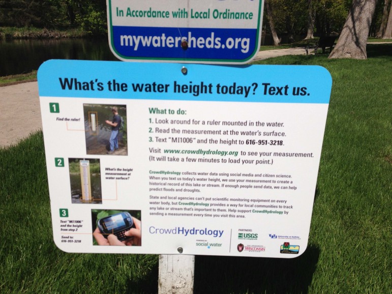
Sign at the Looking Glass explains how citizen scientists can text stream readings for analysis. Credit: Chris Lowry
His new phone app, CrowdHydrology, allows anyone to send information on stream depths in specific locations with the swipe of a thumb.
Jill Martin, an interpretive naturalist for Indian Springs Metropark in White Lake, is setting up
several stations there. An estimated 70,762 visitors came to the park in 2013. If just a fraction of them were to use Lowry’s application, they could provide substantial data for the project.
Martin helps operate the park’s environmental discovery center, which educates the public on river and stream ecology.
“We plan on putting our stations where people regularly walk,” Martin said. “We would also like to include one where we take students, and also to include a cellphone tour where visitors put in a number and get more information on watersheds in Michigan and stream levels.”
These citizen scientists can view the closest stream gauging station that Lowry’s program runs in partnership with the U.S. Geological Survey. There are 19 in Michigan, 13 in New York and 17 in Wisconsin.
Michigan sites include several each in Boyne Valley, Frankfort and Onekama. Among the others are the Kalamazoo Nature Center, Plaster Creek in Grand Rapids and Potter Park Zoo in Lansing.
Each has a sign with brief instructions on how to use a phone to report what the gauge shows as the water’s depth. The gauge is simply a ruler mounted in the stream.
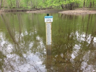
Water depth gauge in the Red Cedar River at the Harris Nature Center Meridian Township. Credit: Chris Lowry
Volunteers can then access the CrowdHydrology app to send in the depth. With a smartphone, the location, time and date are sent automatically. Non-smartphone users can text the water height, location and date.
Five minutes after citizen scientists send in their readings, the data is viewable on the CrowdHydrology webpage. The information is useful for seeing how rain and snowmelt increases stream levels and if the water level is appropriate for activities like fishing or canoeing. Researchers, parks officials, educators and other citizen scientists can use it for free.
“We first started looking at water levels in the Great Lake states,” Lowry said. “Those were our core states. This started out as a Great Lakes project, and it’s starting to expand.”
Lowry’s colleagues have helped spread the concept to a site in Utah and four in Iowa.
After seeing other successful data crowdsourcing projects like ones used in California and Maine to record road kill, Lowry and co-founder Michael Fienen, a research hydrologist for the U.S. Geological Survey, created the app which is available for all mobile platforms.
Researchers with a special interest in the Great Lakes region would be interested in using the stream data, Lowry said. Citizen scientists who visit recreational areas are his targets for making the project work.
Howard Reeves, an assistant professor of civil and environmental engineering at Michigan State University, supports Lowry’s work by instructing other educators about the project and its uses.
“I’ve always had personal motivation to help educators by helping them see and experience
themselves,” Reeves said.
But another important part of education is teaching others how to use these resources. The groups Reeves teaches can further facilitate the CrowdHydrology project.
If recreational areas were to “put a number of river gauges out in different watersheds, we can learn something from those observations,” Reeves said.
To contribute stream data, citizen scientists can find the nearest station on the CrowdHydrology website to make sure it’s open. Many stations are still being set up.
Chelsea Mongeau writes for Great Lakes Echo.
Additional resources for CNS editors.
CrowdHydrology: http://crowdhydrology.geology.buffalo.edu:8040/